Humans feel a sense of awe when they are confronted by things that make them feel small.
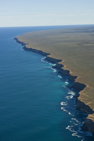
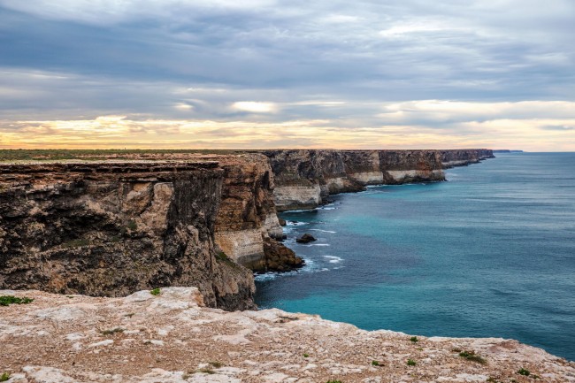
Looking up into the depths of a velvet black, star-studded desert sky will do it. Seeing expanses of ocean or isolated, pristine beaches with nobody in sight, or endless kilometres of massive cliffs being pounded by ocean waves…all of these things will do it.
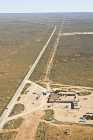
If you want to expand your mental horizons by being made to feel really small, there’s no better place to do it than on the 1,100km Nullarbor Plain, on a roadtrip between Perth and Adelaide.
You can take in the endless cliffs of the Great Australian Bight, knowing that the rolling waves that you see crashing against its base have travelled unimpeded through the vastness of the Southern Ocean, possibly all the way from Antarctica.
 The road trip is a celebration of the senses and an introduction to a landscape that has shaped how Australians perceive themselves, even though most of us have grown up and live in coastal cities on the eastern seaboard.
While the prospect of crossing one of Australia’s iconic frontiers may seem daunting for some, the digital age has helped to iron out some of the corrugations of apprehension and bumps of uncertainty that road travellers in bygone eras have experienced while crossing the Nullarbor. It’s a long way by road between Perth and Adelaide—some 2,793 kilometres—but with the aid of modern technology, you are far from alone.
New digital tools, for use via mobile phone or tablet, have been released in order to help travellers explore one of Australia’s most iconic road journeys—the crossing of the Nullarbor Plain. A digital guide and tourism app now complements traditional printed maps of the Nullarbor Plain and its associated en-route facilities and accommodation sites.
Designed by Regional Development Australia: Whyalla and Eyre Peninsula in a cross-border partnership with Australia’s Golden Outback, the South Australian Tourism Commission and the Outback Communities Authority, the digital guide and app provide information on key journey highlights and visitor services along the route.
The Nullarbor guide and app are logical vehicles to deliver information on this sparse, but fascinating, road trip, given that both South Australia’s Eyre Peninsula and Australia’s Golden Outback region in Western Australia are heavily reliant upon caravaning and self-driving tourism. The aim is to provide detailed, easily-accessible information to more tourists, in order to encourage them to make the journey.
The app offers myriad features focusing on aspects such as safety and mechanical advice; section-by-section overview road-maps that detail fuel and accommodation stops, as well as major towns, information centres and visitor services; there is also reliable information on roadhouses and the facilities they offer, journey highlights and contact details for side-tours, which you can book along the way. The detail of the app is such that if you plan your journey and take your time, you really don’t have to miss anything.
On Map 3, you’ll see the Balladonia Cultural Heritage Museum, which features an interactive display of the area’s Aboriginal and European pioneer history; the influence of the hardy Afghan cameleers; and the crash landing in the region, which occurred in 1979, involving NASA’s Skylab space station.
Also on Map 3 is the Fraser Range Station, on the edge of the Nullarbor. The Fraser Range is a series of granite hills surrounded by the world’s largest eucalyptus hardwood forest. It holds its place in history as the first station settled on the vast, lonely Nullarbor. Its stone buildings, dams, and tanks, constructed by convict and Aboriginal labour both, are a stark reminder of the hardships faced in carving out an existence in extreme isolation. But today at Fraser Range Station, you can camp overnight!
Map 5 highlights the Eyre Bird Observatory, housed in the 1897-built Eyre Telegraph Station. You can also stay in accommodation here, (obviously with advanced bookings preferred). You’ll find it by taking the turn-off that is 17km east of Cocklebiddy. The final 12km of the road is 4WD access only, but 2WD overnight guests can pre-book a free pick-up by phoning 08 9039 3450.
On Map 5, you will also see the Caiguna Blowhole, one of a number of blowholes on the Nullarbor, fed by wave-driven air pushed through the underground labyrinth of limestone caves and fissures beneath the vast plain. It is 5km west of Caiguna, just follow the sign. It’s only a sign, but then, it’s a pretty impressive one. Make sure you stop for a photograph in front of the sign that denotes Australia’s biggest straight stretch of highway, at 145km long.
On Map 6, near the Western Australia-South Australia border, you will see the town of Eucla. The Eucla Telegraph Station, opened in 1877, helped link Western Australia with not only the rest of the continent, but with the rest of the world. The first of 11,000 annual telegraph messages was sent to Perth on December 8th, 1877, with the simple words “Eucla line opened. Hurrah”, just 33 years after Samuel Morse invented the telegraph.
On Map 7, a few kilometres from the Nullarbor Hotel/Motel is Head of Bight, which, if you’re heading west, marks the beginning of the Great Australian Bight Marine National Park.
Following a cliff-top boardwalk to viewing platforms, visitors can watch large groups of Southern Right Whales, which congregate here annually from June to October to give birth and raise their calves. The Head of Bight platforms are one of the best land-based observation points in the world from which to view these majestic sea creatures in their natural environment.
You can see the interactive map online at Nullarbor or download it via the Apple App store or Google Play store.
Photo Credits
Nullarbor and the Great Australian Bight – SA Tourism
Nullarbor and the Great Australian Bight – SA Tourism
Nullarbor and the Great Australian Bight – SA Tourism
Nullarbor Road House and Highway – SA Tourism
Eyre Highway, Nullarbor – Greg Snell/SA Tourism
Camping, The Nullarbor – Greg Snell/SA Tourism
Cliffs near Head of Bight – Greg Snell/SA Tourism
Whale watching, Head of Bight – SA Tourism


Please Share Your Thoughts - Leave A Comment!